

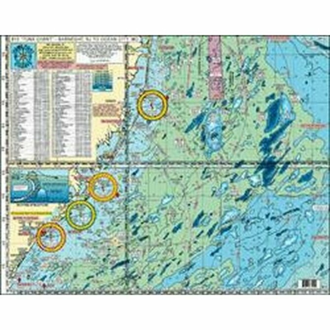
Description
Awesome Bottom Structure - Holes-Shoals-Lumps-Bumps
Shows: Barnegat Inlet, Little Egg Inlet, Absecon Inlet, Great Egg Inlet, Cape May Inlet, Indian River DE Inlet and Ocean City MD inlet
10 Mile radius lines from each inlet
Out 50 Miles
Laminated - waterproof
Color coded depth and contour curve lines
89 + Wrecks and Reefs like: Anastasia, Cow Wreck, Tolton, Maurice Tracy, Bone Wreck, Vixen, Hargraves, Resor, Sumner, Gulf Trade, Chesapeake, San Saba, Choctaw, Spanish Wreck, Blackie Wreck, Salem, Evelyn K, Varanger, Capt. Walt Hendee, Champion, Ammo Wreck, Misty Blue, Jacob Jones, Bimbo, Manhattan, TJ Hooper, USS Nina, Miss Arlene, Muff Diver, USS Blenny, St Augustine, and many more.
Fishing Grounds with DGPS LAT/LON Coordinates: The Slough, The Ledges, Tolton Lump, Barnegat East Ridge, Dusky Hole, ESS Ridge, Table Top, Barnegat Ridge, 45 Square, Triple Lumps, Stone Beds, Sea Isle Lump, Avalon Shoal, Cuma Lumps, The Fingers, Brigantine Shoal, Margarita Lump, Sea Isle Ridge, Jim's Hole, Bent Chunk, NE Lump, Middle Lump, The Pimple, The Cigar, East Lump, The Triple Wrecks, The Elephant Trunk, North Dump Site, 19 Fathom Lump, South Dumpsite, Massey's Canyon, The Tea Cup, The Chicken Bone, Hambone, South Paw, 20 Fathom Fingers, The Hotdog, Hot Dog Bun, Sausages, Jack's Spot, Notch of the Dog